


Duranus - col de l’Autaret

Arnaud Stévenard
User
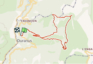

Length
13.2 km

Max alt
1273 m

Uphill gradient
819 m
Km-Effort
24 km

Min alt
493 m

Downhill gradient
819 m
Boucle
Yes
Creation date :
2024-11-03 07:38:26.0
Updated on :
2024-11-03 14:00:18.358
6h19
Difficulty : Easy

FREE GPS app for hiking
 SityTrail
IGN / Geographical institutes
SityTrail Plus
The world is yours!
About
Trail Walking of 13.2 km to be discovered at Provence-Alpes-Côte d'Azur, Maritime Alps, Duranus. This trail is proposed by Arnaud Stévenard.
Positioning
Country:
France
Region :
Provence-Alpes-Côte d'Azur
Department/Province :
Maritime Alps
Municipality :
Duranus
Location:
Unknown
Start:(Dec)
Start:(UTM)
359970 ; 4861790 (32T) N.
Comments