


Ardeche j3 antraigues

cmike39
User
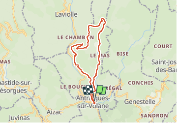

Length
15.2 km

Max alt
907 m

Uphill gradient
568 m
Km-Effort
23 km

Min alt
447 m

Downhill gradient
569 m
Boucle
Yes
Creation date :
2024-11-03 09:35:52.56
Updated on :
2024-11-03 14:50:44.356
5h13
Difficulty : Very difficult

FREE GPS app for hiking
 SityTrail
IGN / Geographical institutes
SityTrail Plus
The world is yours!
About
Trail Walking of 15.2 km to be discovered at Auvergne-Rhône-Alpes, Ardèche, Vallées-d'Antraigues-Asperjoc. This trail is proposed by cmike39.
Positioning
Country:
France
Region :
Auvergne-Rhône-Alpes
Department/Province :
Ardèche
Municipality :
Vallées-d'Antraigues-Asperjoc
Location:
Antraigues-sur-Volane
Start:(Dec)
Start:(UTM)
607608 ; 4952664 (31T) N.
Comments