


Colombier-Chatelot

jacthiry
User
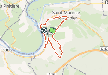

Length
6.8 km

Max alt
361 m

Uphill gradient
102 m
Km-Effort
8.2 km

Min alt
292 m

Downhill gradient
102 m
Boucle
Yes
Creation date :
2024-11-03 13:41:25.195
Updated on :
2024-11-03 15:53:36.162
2h11
Difficulty : Medium

FREE GPS app for hiking
 SityTrail
IGN / Geographical institutes
SityTrail Plus
The world is yours!
About
Trail Walking of 6.8 km to be discovered at Bourgogne-Franche-Comté, Doubs, Saint-Maurice-Colombier. This trail is proposed by jacthiry.
Positioning
Country:
France
Region :
Bourgogne-Franche-Comté
Department/Province :
Doubs
Municipality :
Saint-Maurice-Colombier
Location:
Unknown
Start:(Dec)
Start:(UTM)
321514 ; 5256108 (32T) N.
Comments