


Abwiller

force
User
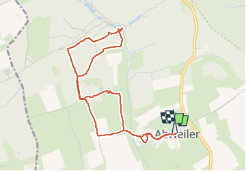

Length
4.7 km

Max alt
324 m

Uphill gradient
88 m
Km-Effort
5.8 km

Min alt
286 m

Downhill gradient
85 m
Boucle
Yes
Creation date :
2024-11-03 14:34:35.806
Updated on :
2024-11-03 15:59:27.385
1h20
Difficulty : Easy

FREE GPS app for hiking
 SityTrail
IGN / Geographical institutes
SityTrail Plus
The world is yours!
About
Trail Walking of 4.7 km to be discovered at Unknown, Canton Esch-sur-Alzette, Bettembourg. This trail is proposed by force.
Positioning
Country:
Luxembourg
Region :
Unknown
Department/Province :
Canton Esch-sur-Alzette
Municipality :
Bettembourg
Location:
Unknown
Start:(Dec)
Start:(UTM)
288683 ; 5490800 (32U) N.
Comments