


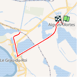
Aigues-Mortes : chemin de halage

frizou83
User

Length
17.6 km

Max alt
7 m

Uphill gradient
71 m
Km-Effort
18.5 km

Min alt
-6 m

Downhill gradient
71 m
Boucle
Yes
Creation date :
2015-05-24 00:00:00.0
Updated on :
2015-05-24 00:00:00.0
4h08
Difficulty : Very easy

FREE GPS app for hiking
 SityTrail
IGN / Geographical institutes
SityTrail Plus
The world is yours!
About
Trail Walking of 17.6 km to be discovered at Occitania, Gard, Aigues-Mortes. This trail is proposed by frizou83.
Positioning
Country:
France
Region :
Occitania
Department/Province :
Gard
Municipality :
Aigues-Mortes
Location:
Unknown
Start:(Dec)
Start:(UTM)
596243 ; 4824244 (31T) N.
Comments