


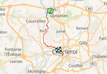
Stationswandeling Courcelles-Motte - Charleroi

FreddyTuerlinckx
User

Length
11.9 km

Max alt
171 m

Uphill gradient
238 m
Km-Effort
15.2 km

Min alt
96 m

Downhill gradient
255 m
Boucle
No
Creation date :
2024-11-05 07:35:53.122
Updated on :
2025-04-15 10:31:34.081
3h26
Difficulty : Easy

FREE GPS app for hiking
 SityTrail
IGN / Geographical institutes
SityTrail Plus
The world is yours!
About
Trail On foot of 11.9 km to be discovered at Wallonia, Hainaut, Courcelles. This trail is proposed by FreddyTuerlinckx.
Positioning
Country:
Belgium
Region :
Wallonia
Department/Province :
Hainaut
Municipality :
Courcelles
Location:
Unknown
Start:(Dec)
Start:(UTM)
599411 ; 5590962 (31U) N.
Comments