


centre ville aubagne selon l'office tourisme

CASSISFRAMBOISE
User
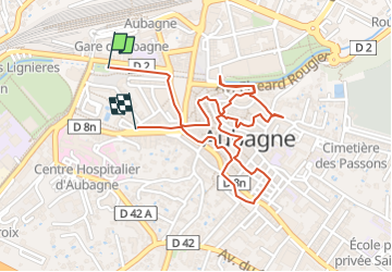

Length
2.6 km

Max alt
131 m

Uphill gradient
44 m
Km-Effort
3.2 km

Min alt
103 m

Downhill gradient
41 m
Boucle
No
Creation date :
2024-11-05 07:43:36.876
Updated on :
2024-11-05 07:44:19.262
43m
Difficulty : Easy

FREE GPS app for hiking
 SityTrail
IGN / Geographical institutes
SityTrail Plus
The world is yours!
About
Trail Walking of 2.6 km to be discovered at Provence-Alpes-Côte d'Azur, Bouches-du-Rhône, Aubagne. This trail is proposed by CASSISFRAMBOISE.
Positioning
Country:
France
Region :
Provence-Alpes-Côte d'Azur
Department/Province :
Bouches-du-Rhône
Municipality :
Aubagne
Location:
Unknown
Start:(Dec)
Start:(UTM)
708054 ; 4796709 (31T) N.
Comments