


les arcs crêtes de taradeau

vincente204
User
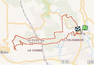

Length
13 km

Max alt
247 m

Uphill gradient
330 m
Km-Effort
17.4 km

Min alt
74 m

Downhill gradient
333 m
Boucle
Yes
Creation date :
2024-11-05 07:59:44.596
Updated on :
2024-11-05 14:00:43.186
5h13
Difficulty : Difficult

FREE GPS app for hiking
 SityTrail
IGN / Geographical institutes
SityTrail Plus
The world is yours!
About
Trail Walking of 13 km to be discovered at Provence-Alpes-Côte d'Azur, Var, Les Arcs-sur-Argens. This trail is proposed by vincente204.
Description
facile
Positioning
Country:
France
Region :
Provence-Alpes-Côte d'Azur
Department/Province :
Var
Municipality :
Les Arcs-sur-Argens
Location:
Unknown
Start:(Dec)
Start:(UTM)
296221 ; 4815296 (32T) N.
Comments