


etueffont ́Daniel

danif
User
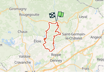

Length
21 km

Max alt
529 m

Uphill gradient
466 m
Km-Effort
27 km

Min alt
368 m

Downhill gradient
452 m
Boucle
Yes
Creation date :
2024-11-05 07:52:13.57
Updated on :
2024-11-05 14:21:34.972
6h28
Difficulty : Very difficult

FREE GPS app for hiking
 SityTrail
IGN / Geographical institutes
SityTrail Plus
The world is yours!
About
Trail Walking of 21 km to be discovered at Bourgogne-Franche-Comté, Territoire-de-Belfort, Étueffont. This trail is proposed by danif.
Positioning
Country:
France
Region :
Bourgogne-Franche-Comté
Department/Province :
Territoire-de-Belfort
Municipality :
Étueffont
Location:
Unknown
Start:(Dec)
Start:(UTM)
343892 ; 5287550 (32T) N.
Comments