


Besançon

PatriceCocuaud
User
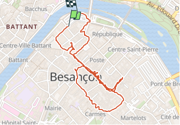

Length
3.1 km

Max alt
256 m

Uphill gradient
17 m
Km-Effort
3.4 km

Min alt
239 m

Downhill gradient
24 m
Boucle
Yes
Creation date :
2024-11-05 13:19:49.231
Updated on :
2024-11-05 19:13:03.71
3h49
Difficulty : Very easy

FREE GPS app for hiking
 SityTrail
IGN / Geographical institutes
SityTrail Plus
The world is yours!
About
Trail Walking of 3.1 km to be discovered at Bourgogne-Franche-Comté, Doubs, Besançon. This trail is proposed by PatriceCocuaud.
Positioning
Country:
France
Region :
Bourgogne-Franche-Comté
Department/Province :
Doubs
Municipality :
Besançon
Location:
Unknown
Start:(Dec)
Start:(UTM)
274758 ; 5236237 (32T) N.
Comments