Monteils

Mariecoyac
User
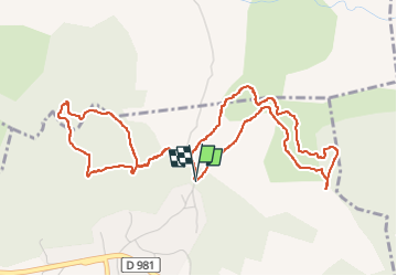

Length
6.3 km

Max alt
247 m

Uphill gradient
104 m
Km-Effort
7.7 km

Min alt
181 m

Downhill gradient
102 m
Boucle
Yes
Creation date :
2024-11-06 08:32:42.981
Updated on :
2024-11-06 10:28:36.249
1h54
Difficulty : Easy

FREE GPS app for hiking
 SityTrail
IGN / Geographical institutes
SityTrail Plus
The world is yours!
About
Trail Walking of 6.3 km to be discovered at Occitania, Gard, Monteils. This trail is proposed by Mariecoyac.
Positioning
Country:
France
Region :
Occitania
Department/Province :
Gard
Municipality :
Monteils
Location:
Unknown
Start:(Dec)
Start:(UTM)
595043 ; 4883377 (31T) N.
Comments