


Cravant-les-Coteaux - Zig zag les Vallées de Basse - 27.8km 400m 6h10 (55mn) - 2024 11 06

Orcal37
User GUIDE
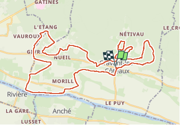

Length
28 km

Max alt
119 m

Uphill gradient
398 m
Km-Effort
33 km

Min alt
30 m

Downhill gradient
398 m
Boucle
Yes
Creation date :
2024-11-06 08:43:01.891
Updated on :
2024-11-11 15:00:58.037
6h10
Difficulty : Easy

FREE GPS app for hiking
 SityTrail
IGN / Geographical institutes
SityTrail Plus
The world is yours!
About
Trail Walking of 28 km to be discovered at Centre-Loire Valley, Indre-et-Loire, Cravant-les-Côteaux. This trail is proposed by Orcal37.
Description
Cravant-les-Coteaux - Zig zag - les Vallées de Basse (Chinon) - via GR48 et PRs - 27.8km 400m 6h10 (55mn) - 2024 11 06
Photos
 - 2024 11 06 - Photo 1")
 - 2024 11 06 - Photo 2")
 - 2024 11 06 - Photo 3")
 - 2024 11 06 - Photo 4")
 - 2024 11 06 - Photo 5")
 - 2024 11 06 - Photo 6")
 - 2024 11 06 - Photo 7")
 - 2024 11 06 - Photo 8")
 - 2024 11 06 - Photo 9")
 - 2024 11 06 - Photo 10")
 - 2024 11 06 - Photo 11")
 - 2024 11 06 - Photo 12")
 - 2024 11 06 - Photo 13")
Positioning
Country:
France
Region :
Centre-Loire Valley
Department/Province :
Indre-et-Loire
Municipality :
Cravant-les-Côteaux
Location:
Unknown
Start:(Dec)
Start:(UTM)
298802 ; 5226214 (31T) N.
Comments