


2023-01-26 Randonneur Hyérois

lygi
User
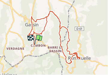

Length
14.3 km

Max alt
316 m

Uphill gradient
619 m
Km-Effort
23 km

Min alt
49 m

Downhill gradient
619 m
Boucle
Yes
Creation date :
2024-11-06 18:00:10.49
Updated on :
2024-11-06 18:00:26.993

FREE GPS app for hiking
 SityTrail
IGN / Geographical institutes
SityTrail Plus
The world is yours!
About
Trail of 14.3 km to be discovered at Provence-Alpes-Côte d'Azur, Var, Gassin. This trail is proposed by lygi.


Positioning
Country:
France
Region :
Provence-Alpes-Côte d'Azur
Department/Province :
Var
Municipality :
Gassin
Location:
Unknown
Start:(Dec)
Start:(UTM)
304055 ; 4788158 (32T) N.
Comments