


Étang bleu par le Cirque d’Embans

lebarça
User
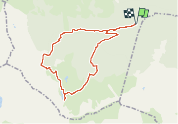

Length
10.8 km

Max alt
1813 m

Uphill gradient
789 m
Km-Effort
21 km

Min alt
1035 m

Downhill gradient
786 m
Boucle
Yes
Creation date :
2024-11-06 08:04:28.0
Updated on :
2024-11-06 18:35:23.743
4h50
Difficulty : Medium

FREE GPS app for hiking
 SityTrail
IGN / Geographical institutes
SityTrail Plus
The world is yours!
About
Trail Walking of 10.8 km to be discovered at Occitania, Ariège, Rabat-les-Trois-Seigneurs. This trail is proposed by lebarça.
Positioning
Country:
France
Region :
Occitania
Department/Province :
Ariège
Municipality :
Rabat-les-Trois-Seigneurs
Location:
Unknown
Start:(Dec)
Start:(UTM)
376226 ; 4744218 (31T) N.
Comments