


G2 Sigy le Châtel

Malone71
User
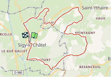

Length
12.4 km

Max alt
409 m

Uphill gradient
324 m
Km-Effort
16.7 km

Min alt
212 m

Downhill gradient
322 m
Boucle
Yes
Creation date :
2024-11-04 12:46:23.984
Updated on :
2024-11-07 15:33:39.029
2h35
Difficulty : Difficult

FREE GPS app for hiking
 SityTrail
IGN / Geographical institutes
SityTrail Plus
The world is yours!
About
Trail Walking of 12.4 km to be discovered at Bourgogne-Franche-Comté, Saône-et-Loire, Sigy-le-Châtel. This trail is proposed by Malone71.
Positioning
Country:
France
Region :
Bourgogne-Franche-Comté
Department/Province :
Saône-et-Loire
Municipality :
Sigy-le-Châtel
Location:
Unknown
Start:(Dec)
Start:(UTM)
620595 ; 5156959 (31T) N.
Comments