


Vautour

renaudma
User
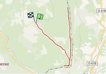

Length
6 km

Max alt
871 m

Uphill gradient
327 m
Km-Effort
10.4 km

Min alt
686 m

Downhill gradient
332 m
Boucle
Yes
Creation date :
2024-11-07 11:50:02.0
Updated on :
2024-11-07 16:30:05.604
2h16
Difficulty : Medium

FREE GPS app for hiking
 SityTrail
IGN / Geographical institutes
SityTrail Plus
The world is yours!
About
Trail Walking of 6 km to be discovered at Auvergne-Rhône-Alpes, Drôme, Saint-May. This trail is proposed by renaudma.
Positioning
Country:
France
Region :
Auvergne-Rhône-Alpes
Department/Province :
Drôme
Municipality :
Saint-May
Location:
Unknown
Start:(Dec)
Start:(UTM)
686234 ; 4921677 (31T) N.
Comments