


LaBouverieRando2Bagnols-en-Forêt Randonnée-Tracé

GeorgesV.
User
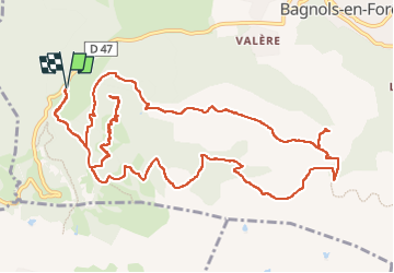

Length
17.4 km

Max alt
440 m

Uphill gradient
619 m
Km-Effort
26 km

Min alt
202 m

Downhill gradient
618 m
Boucle
Yes
Creation date :
2024-11-07 20:59:19.0
Updated on :
2024-11-07 20:59:20.586

FREE GPS app for hiking
 SityTrail
IGN / Geographical institutes
SityTrail Plus
The world is yours!
About
Trail of 17.4 km to be discovered at Provence-Alpes-Côte d'Azur, Var, Bagnols-en-Forêt. This trail is proposed by GeorgesV..
Positioning
Country:
France
Region :
Provence-Alpes-Côte d'Azur
Department/Province :
Var
Municipality :
Bagnols-en-Forêt
Location:
Unknown
Start:(Dec)
Start:(UTM)
310502 ; 4822180 (32T) N.
Comments