


Vallon Pont d arc Largentière Balazuc Ruoms Vallon Pont d Arc

topolino
User
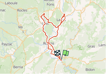

Length
68 km

Max alt
281 m

Uphill gradient
1185 m
Km-Effort
84 km

Min alt
83 m

Downhill gradient
1185 m
Boucle
Yes
Creation date :
2024-11-08 09:48:26.0
Updated on :
2024-11-08 09:52:24.545
3h00
Difficulty : Difficult

FREE GPS app for hiking
 SityTrail
IGN / Geographical institutes
SityTrail Plus
The world is yours!
About
Trail Road bike of 68 km to be discovered at Auvergne-Rhône-Alpes, Ardèche, Vallon-Pont-d'Arc. This trail is proposed by topolino.
Positioning
Country:
France
Region :
Auvergne-Rhône-Alpes
Department/Province :
Ardèche
Municipality :
Vallon-Pont-d'Arc
Location:
Unknown
Start:(Dec)
Start:(UTM)
611586 ; 4917209 (31T) N.
Comments