


Grendelbruch pitons du Falkenstein

apa
User
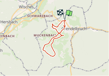

Length
10.8 km

Max alt
836 m

Uphill gradient
365 m
Km-Effort
15.6 km

Min alt
540 m

Downhill gradient
361 m
Boucle
Yes
Creation date :
2024-11-08 11:27:13.505
Updated on :
2024-11-08 11:27:46.813
3h32
Difficulty : Medium

FREE GPS app for hiking
 SityTrail
IGN / Geographical institutes
SityTrail Plus
The world is yours!
About
Trail Walking of 10.8 km to be discovered at Grand Est, Bas-Rhin, Grendelbruch. This trail is proposed by apa.
Description
panoramique
Positioning
Country:
France
Region :
Grand Est
Department/Province :
Bas-Rhin
Municipality :
Grendelbruch
Location:
Unknown
Start:(Dec)
Start:(UTM)
375404 ; 5373209 (32U) N.
Comments