


marche rapide

bubufred
User
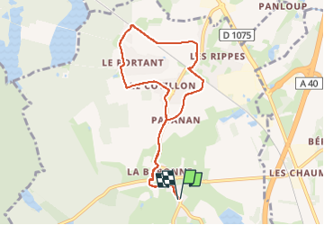

Length
8.2 km

Max alt
256 m

Uphill gradient
40 m
Km-Effort
8.8 km

Min alt
245 m

Downhill gradient
41 m
Boucle
Yes
Creation date :
2024-11-08 13:55:16.13
Updated on :
2024-11-08 15:07:05.451
1h08
Difficulty : Very easy

FREE GPS app for hiking
 SityTrail
IGN / Geographical institutes
SityTrail Plus
The world is yours!
About
Trail Nordic walking of 8.2 km to be discovered at Auvergne-Rhône-Alpes, Ain, Certines. This trail is proposed by bubufred.
Positioning
Country:
France
Region :
Auvergne-Rhône-Alpes
Department/Province :
Ain
Municipality :
Certines
Location:
Unknown
Start:(Dec)
Start:(UTM)
675091 ; 5110994 (31T) N.
Comments