


les roches depuis la ceuille

gilbert57
User
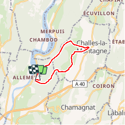

Length
8.7 km

Max alt
561 m

Uphill gradient
369 m
Km-Effort
13.5 km

Min alt
315 m

Downhill gradient
308 m
Boucle
No
Creation date :
2015-06-02 00:00:00.0
Updated on :
2015-06-02 00:00:00.0
2h41
Difficulty : Unknown

FREE GPS app for hiking
 SityTrail
IGN / Geographical institutes
SityTrail Plus
The world is yours!
About
Trail Walking of 8.7 km to be discovered at Auvergne-Rhône-Alpes, Ain, Poncin. This trail is proposed by gilbert57.
Positioning
Country:
France
Region :
Auvergne-Rhône-Alpes
Department/Province :
Ain
Municipality :
Poncin
Location:
Unknown
Start:(Dec)
Start:(UTM)
687302 ; 5108949 (31T) N.
Comments