


Boucle Saou

ophness
User
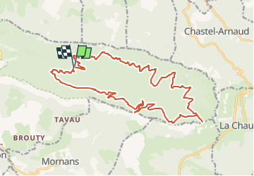

Length
22 km

Max alt
1313 m

Uphill gradient
997 m
Km-Effort
36 km

Min alt
470 m

Downhill gradient
986 m
Boucle
Yes
Creation date :
2024-11-08 17:28:20.0
Updated on :
2024-11-09 14:43:44.523

FREE GPS app for hiking
 SityTrail
IGN / Geographical institutes
SityTrail Plus
The world is yours!
About
Trail of 22 km to be discovered at Auvergne-Rhône-Alpes, Drôme, Saou. This trail is proposed by ophness.
Positioning
Country:
France
Region :
Auvergne-Rhône-Alpes
Department/Province :
Drôme
Municipality :
Saou
Location:
Unknown
Start:(Dec)
Start:(UTM)
669002 ; 4946512 (31T) N.
Comments