


pour Christine

hgm
User

Length
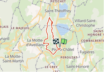
10.5 km

Max alt
1275 m

Uphill gradient
346 m
Km-Effort
15.1 km

Min alt
942 m

Downhill gradient
346 m
Boucle
Yes
Creation date :
2024-11-07 08:31:07.435
Updated on :
2024-11-10 08:38:39.621
72h06
Difficulty : Difficult

FREE GPS app for hiking
 SityTrail
IGN / Geographical institutes
SityTrail Plus
The world is yours!
About
Trail Walking of 10.5 km to be discovered at Auvergne-Rhône-Alpes, Isère, Pierre-Châtel. This trail is proposed by hgm.
Positioning
Country:
France
Region :
Auvergne-Rhône-Alpes
Department/Province :
Isère
Municipality :
Pierre-Châtel
Location:
Unknown
Start:(Dec)
Start:(UTM)
718872 ; 4981992 (31T) N.
Comments