


gairaut

clintest
User

Length
14.5 km

Max alt
841 m

Uphill gradient
725 m
Km-Effort
24 km

Min alt
228 m

Downhill gradient
714 m
Boucle
Yes
Creation date :
2024-11-10 07:50:22.838
Updated on :
2024-11-10 15:10:23.187
7h05
Difficulty : Very difficult

FREE GPS app for hiking
 SityTrail
IGN / Geographical institutes
SityTrail Plus
The world is yours!
About
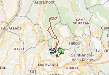
Trail Walking of 14.5 km to be discovered at Provence-Alpes-Côte d'Azur, Maritime Alps, Nice. This trail is proposed by clintest.
Positioning
Country:
France
Region :
Provence-Alpes-Côte d'Azur
Department/Province :
Maritime Alps
Municipality :
Nice
Location:
Unknown
Start:(Dec)
Start:(UTM)
359766 ; 4844163 (32T) N.
Comments