Trail Walking Ban-sur-Meurthe-Clefcy - SURCENEUX SERICHAMPS AR - Photo

SURCENEUX SERICHAMPS AR

© OpenStreetMap contributors
Length
Length
17.6 km
Max alt
Max alt
1148 m
Uphill gradient
Uphill gradient
777 m
Km-Effort
Km-Effort  
28 km
Min alt
Min alt
630 m
Downhill gradient
Downhill gradient
775 m
Boucle
Boucle
Yes
Creation date :
2024-11-10 08:13:24.323
Updated on :
2024-11-10 15:57:41.15

(0 Reviews)

Walking
Walking
3h50
Difficulty : Medium

Scan this QR Code to open this trail in the SityTrail application

FREE GPS app for hiking

Logo SityTrail SityTrail

IGN / Geographical institutes

Download SityTrail from the App Store Download SityTrail from Google Play

Logo SityTrail SityTrail Plus

The world is yours!

Download SityTrail from the App Store Download SityTrail from Google Play Download SityTrail on Huawei AppGallery

About

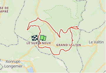
Trail Walking of 17.6 km to be discovered at Grand Est, Vosges, Ban-sur-Meurthe-Clefcy. This trail is proposed by surceneux.

Description

SURCENEUX COL DU PORT DES PLANCHES CARREFOUR IRENEE DUVOID GRD VALTIN WIMBAR CHEMIN DE SERICHAMPS SERICHAMPS LE GRD BOROGE  LA BRULEE SCIERIE DU LANCOIR PAR SENTIER DU SAGARD RF DES BLANCHES FONTAINES  LES BASSES DE L'EAU LE SURCENEUX

Elevation profile

Positioning

Country:
France
Region :
Grand Est
Department/Province :
Vosges
Municipality :
Ban-sur-Meurthe-Clefcy
Location:
Unknown
Start:(UTM)
347853 ; 5329047 (32U) N.


Close
My subscriptions