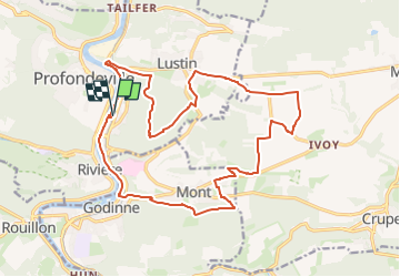
Lustin/Mont

geoffrayLayeux
User

Length
18.7 km

Max alt
279 m

Uphill gradient
438 m
Km-Effort
25 km

Min alt
83 m

Downhill gradient
438 m
Boucle
Yes
Creation date :
2024-11-10 16:12:55.723
Updated on :
2024-11-10 16:14:36.402
5h35
Difficulty : Very difficult

FREE GPS app for hiking
 SityTrail
IGN / Geographical institutes
SityTrail Plus
The world is yours!
About
Trail Walking of 18.7 km to be discovered at Wallonia, Namur, Profondeville. This trail is proposed by geoffrayLayeux.
Positioning
Country:
Belgium
Region :
Wallonia
Department/Province :
Namur
Municipality :
Profondeville
Location:
Lustin
Start:(Dec)
Start:(UTM)
633473 ; 5581335 (31U) N.
Comments