Font du Broc Roselyne actuel

mb83serre
User GUIDE
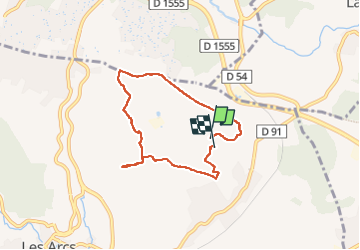

Length
9.5 km

Max alt
220 m

Uphill gradient
191 m
Km-Effort
12 km

Min alt
135 m

Downhill gradient
190 m
Boucle
Yes
Creation date :
2024-11-11 07:36:27.861
Updated on :
2025-04-01 10:29:25.826
2h43
Difficulty : Medium

FREE GPS app for hiking
 SityTrail
IGN / Geographical institutes
SityTrail Plus
The world is yours!
About
Trail Walking of 9.5 km to be discovered at Provence-Alpes-Côte d'Azur, Var, Les Arcs-sur-Argens. This trail is proposed by mb83serre.
Description
Longer le grillage qui fait le tour des ruines d'antan.
Positioning
Country:
France
Region :
Provence-Alpes-Côte d'Azur
Department/Province :
Var
Municipality :
Les Arcs-sur-Argens
Location:
Unknown
Start:(Dec)
Start:(UTM)
298403 ; 4816645 (32T) N.
Comments