


signal Villard

ascq
User
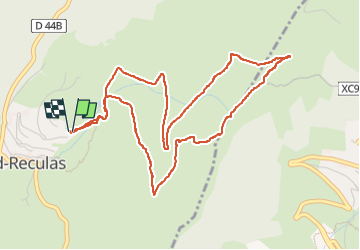

Length
5.8 km

Max alt
2028 m

Uphill gradient
455 m
Km-Effort
11.8 km

Min alt
1546 m

Downhill gradient
463 m
Boucle
Yes
Creation date :
2024-11-11 10:20:12.077
Updated on :
2024-11-11 12:29:56.259
2h09
Difficulty : Medium

FREE GPS app for hiking
 SityTrail
IGN / Geographical institutes
SityTrail Plus
The world is yours!
About
Trail Walking of 5.8 km to be discovered at Auvergne-Rhône-Alpes, Isère, Villard-Reculas. This trail is proposed by ascq.
Positioning
Country:
France
Region :
Auvergne-Rhône-Alpes
Department/Province :
Isère
Municipality :
Villard-Reculas
Location:
Unknown
Start:(Dec)
Start:(UTM)
266822 ; 4997597 (32T) N.
Comments