


Tour du Mont denier en vtt

laurentnerual
User
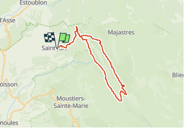

Length
34 km

Max alt
1539 m

Uphill gradient
984 m
Km-Effort
47 km

Min alt
944 m

Downhill gradient
985 m
Boucle
Yes
Creation date :
2024-11-11 09:43:51.296
Updated on :
2024-11-11 15:41:04.658
5h18
Difficulty : Very difficult

FREE GPS app for hiking
 SityTrail
IGN / Geographical institutes
SityTrail Plus
The world is yours!
About
Trail Mountain bike of 34 km to be discovered at Provence-Alpes-Côte d'Azur, Alpes-de-Haute-Provence, Saint-Jurs. This trail is proposed by laurentnerual.
Description
36 km et 936 m de dénivelé positif
Positioning
Country:
France
Region :
Provence-Alpes-Côte d'Azur
Department/Province :
Alpes-de-Haute-Provence
Municipality :
Saint-Jurs
Location:
Unknown
Start:(Dec)
Start:(UTM)
275428 ; 4864271 (32T) N.
Comments