


Sommières Junas

daniel34
User
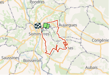

Length
14.7 km

Max alt
102 m

Uphill gradient
207 m
Km-Effort
17.4 km

Min alt
34 m

Downhill gradient
208 m
Boucle
Yes
Creation date :
2024-11-12 08:48:43.0
Updated on :
2024-11-12 14:35:13.388
4h13
Difficulty : Easy

FREE GPS app for hiking
 SityTrail
IGN / Geographical institutes
SityTrail Plus
The world is yours!
About
Trail Walking of 14.7 km to be discovered at Occitania, Gard, Sommières. This trail is proposed by daniel34.
Description
Superbe rando jolis paysages!
Photos


Positioning
Country:
France
Region :
Occitania
Department/Province :
Gard
Municipality :
Sommières
Location:
Unknown
Start:(Dec)
Start:(UTM)
587973 ; 4848392 (31T) N.
Comments