


Le Mas Raynal - Guilhaumard

Alain28/01
User
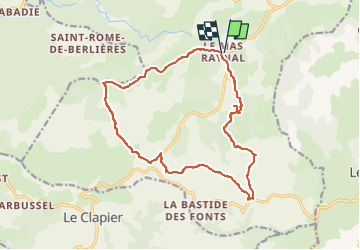

Length
16.8 km

Max alt
843 m

Uphill gradient
286 m
Km-Effort
21 km

Min alt
721 m

Downhill gradient
284 m
Boucle
Yes
Creation date :
2024-11-12 16:34:56.092
Updated on :
2024-11-12 16:36:27.875
4h41
Difficulty : Medium

FREE GPS app for hiking
 SityTrail
IGN / Geographical institutes
SityTrail Plus
The world is yours!
About
Trail Walking of 16.8 km to be discovered at Occitania, Aveyron, Cornus. This trail is proposed by Alain28/01.
Positioning
Country:
France
Region :
Occitania
Department/Province :
Aveyron
Municipality :
Cornus
Location:
Unknown
Start:(Dec)
Start:(UTM)
517464 ; 4857697 (31T) N.
Comments