


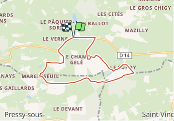
RA Tour par Le Supoy

dfluzin
User

Length
7.5 km

Max alt
286 m

Uphill gradient
104 m
Km-Effort
8.9 km

Min alt
231 m

Downhill gradient
104 m
Boucle
Yes
Creation date :
2015-05-27 00:00:00.0
Updated on :
2015-05-27 00:00:00.0
1h56
Difficulty : Unknown

FREE GPS app for hiking
 SityTrail
IGN / Geographical institutes
SityTrail Plus
The world is yours!
About
Trail Walking of 7.5 km to be discovered at Bourgogne-Franche-Comté, Saône-et-Loire, Saint-André-le-Désert. This trail is proposed by dfluzin.
Positioning
Country:
France
Region :
Bourgogne-Franche-Comté
Department/Province :
Saône-et-Loire
Municipality :
Saint-André-le-Désert
Location:
Unknown
Start:(Dec)
Start:(UTM)
617325 ; 5150120 (31T) N.
Comments