


sous autoroute

bubufred
User
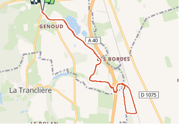

Length
10.2 km

Max alt
266 m

Uphill gradient
61 m
Km-Effort
11.1 km

Min alt
247 m

Downhill gradient
61 m
Boucle
Yes
Creation date :
2024-11-13 07:12:59.984
Updated on :
2024-11-13 08:25:31.835
1h08
Difficulty : Very easy

FREE GPS app for hiking
 SityTrail
IGN / Geographical institutes
SityTrail Plus
The world is yours!
About
Trail Trail of 10.2 km to be discovered at Auvergne-Rhône-Alpes, Ain, Certines. This trail is proposed by bubufred.
Positioning
Country:
France
Region :
Auvergne-Rhône-Alpes
Department/Province :
Ain
Municipality :
Certines
Location:
Unknown
Start:(Dec)
Start:(UTM)
675101 ; 5110976 (31T) N.
Comments