


ravine tabac

XavierFaidix
User
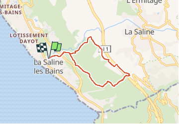

Length
8.5 km

Max alt
301 m

Uphill gradient
326 m
Km-Effort
12.9 km

Min alt
9 m

Downhill gradient
325 m
Boucle
Yes
Creation date :
2024-11-13 12:25:18.094
Updated on :
2024-11-13 14:39:31.556
2h13
Difficulty : Difficult

FREE GPS app for hiking
 SityTrail
IGN / Geographical institutes
SityTrail Plus
The world is yours!
About
Trail Walking of 8.5 km to be discovered at Réunion, Unknown, Saint-Paul. This trail is proposed by XavierFaidix.
Positioning
Country:
France
Region :
Réunion
Department/Province :
Unknown
Municipality :
Saint-Paul
Location:
Unknown
Start:(Dec)
Start:(UTM)
316929 ; 7666632 (40K) S.
Comments