


courmont groupe

jacthiry
User
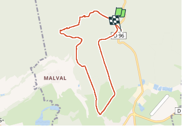

Length
8.1 km

Max alt
469 m

Uphill gradient
173 m
Km-Effort
10.4 km

Min alt
382 m

Downhill gradient
163 m
Boucle
No
Creation date :
2024-11-14 12:57:59.752
Updated on :
2024-11-14 15:18:23.455
2h18
Difficulty : Medium

FREE GPS app for hiking
 SityTrail
IGN / Geographical institutes
SityTrail Plus
The world is yours!
About
Trail Walking of 8.1 km to be discovered at Bourgogne-Franche-Comté, Haute-Saône, Saulnot. This trail is proposed by jacthiry.
Positioning
Country:
France
Region :
Bourgogne-Franche-Comté
Department/Province :
Haute-Saône
Municipality :
Saulnot
Location:
Unknown
Start:(Dec)
Start:(UTM)
321724 ; 5273038 (32T) N.
Comments