


Aureille tour de gué 3

sergioleone
User
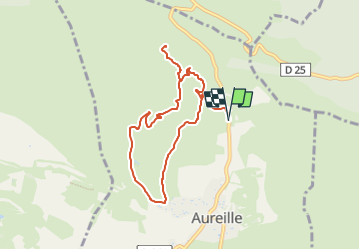

Length
8.5 km

Max alt
332 m

Uphill gradient
261 m
Km-Effort
12 km

Min alt
152 m

Downhill gradient
264 m
Boucle
Yes
Creation date :
2024-11-15 13:57:51.578
Updated on :
2024-11-15 13:59:09.989
2h43
Difficulty : Easy

FREE GPS app for hiking
 SityTrail
IGN / Geographical institutes
SityTrail Plus
The world is yours!
About
Trail On foot of 8.5 km to be discovered at Provence-Alpes-Côte d'Azur, Bouches-du-Rhône, Aureille. This trail is proposed by sergioleone.
Positioning
Country:
France
Region :
Provence-Alpes-Côte d'Azur
Department/Province :
Bouches-du-Rhône
Municipality :
Aureille
Location:
Unknown
Start:(Dec)
Start:(UTM)
657060 ; 4842534 (31T) N.
Comments