


La Ciotat Voie douce

mhetpierre
User
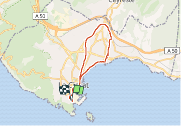

Length
12.1 km

Max alt
89 m

Uphill gradient
163 m
Km-Effort
14.3 km

Min alt
0 m

Downhill gradient
163 m
Boucle
Yes
Creation date :
2024-11-15 09:48:44.0
Updated on :
2024-11-16 10:42:06.341
3h14
Difficulty : Difficult

FREE GPS app for hiking
 SityTrail
IGN / Geographical institutes
SityTrail Plus
The world is yours!
About
Trail Walking of 12.1 km to be discovered at Provence-Alpes-Côte d'Azur, Bouches-du-Rhône, La Ciotat. This trail is proposed by mhetpierre.
Positioning
Country:
France
Region :
Provence-Alpes-Côte d'Azur
Department/Province :
Bouches-du-Rhône
Municipality :
La Ciotat
Location:
Unknown
Start:(Dec)
Start:(UTM)
711768 ; 4782752 (31T) N.
Comments