


Le pont Marcilly par azergues

ophness
User
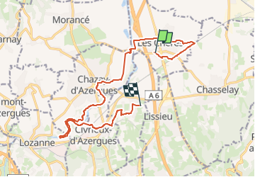

Length
16.4 km

Max alt
265 m

Uphill gradient
201 m
Km-Effort
18.9 km

Min alt
177 m

Downhill gradient
165 m
Boucle
No
Creation date :
2024-11-15 16:03:58.0
Updated on :
2024-11-15 16:03:59.927

FREE GPS app for hiking
 SityTrail
IGN / Geographical institutes
SityTrail Plus
The world is yours!
About
Trail of 16.4 km to be discovered at Auvergne-Rhône-Alpes, Rhône, Les Chères. This trail is proposed by ophness.
Positioning
Country:
France
Region :
Auvergne-Rhône-Alpes
Department/Province :
Rhône
Municipality :
Les Chères
Location:
Unknown
Start:(Dec)
Start:(UTM)
635068 ; 5082922 (31T) N.
Comments