


Bellefond depuis Perquelin

GOHIER
User
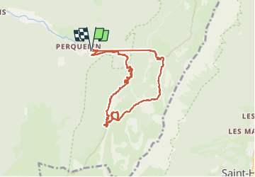

Length
9.1 km

Max alt
1802 m

Uphill gradient
901 m
Km-Effort
21 km

Min alt
1003 m

Downhill gradient
905 m
Boucle
Yes
Creation date :
2024-11-04 09:19:26.0
Updated on :
2024-11-16 09:08:48.064

FREE GPS app for hiking
 SityTrail
IGN / Geographical institutes
SityTrail Plus
The world is yours!
About
Trail of 9.1 km to be discovered at Auvergne-Rhône-Alpes, Isère, Saint-Pierre-de-Chartreuse. This trail is proposed by GOHIER.
Description
En boucle par le Prayet. Avec Patou, Jean-Louis et Frédéric.
Positioning
Country:
France
Region :
Auvergne-Rhône-Alpes
Department/Province :
Isère
Municipality :
Saint-Pierre-de-Chartreuse
Location:
Unknown
Start:(Dec)
Start:(UTM)
723173 ; 5023656 (31T) N.
Comments