


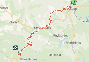
J4 Stevenson: La Bastide Puylaurent - les Alpiers

ARPF
User

Length
28 km

Max alt
1412 m

Uphill gradient
936 m
Km-Effort
40 km

Min alt
1019 m

Downhill gradient
732 m
Boucle
No
Creation date :
2015-05-28 00:00:00.0
Updated on :
2015-05-28 00:00:00.0
8h23
Difficulty : Very difficult

FREE GPS app for hiking
 SityTrail
IGN / Geographical institutes
SityTrail Plus
The world is yours!
About
Trail Walking of 28 km to be discovered at Occitania, Lozère, La Bastide-Puylaurent. This trail is proposed by ARPF.
Description
Indice Effort= 97 P3 T2
Positioning
Country:
France
Region :
Occitania
Department/Province :
Lozère
Municipality :
La Bastide-Puylaurent
Location:
Unknown
Start:(Dec)
Start:(UTM)
571844 ; 4938014 (31T) N.
Comments