


J5 Stevenson: Les Alpiers - Pont de Monvert

ARPF
User
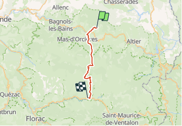

Length
24 km

Max alt
1699 m

Uphill gradient
689 m
Km-Effort
34 km

Min alt
873 m

Downhill gradient
1025 m
Boucle
No
Creation date :
2015-05-28 00:00:00.0
Updated on :
2015-05-28 00:00:00.0
7h02
Difficulty : Difficult

FREE GPS app for hiking
 SityTrail
IGN / Geographical institutes
SityTrail Plus
The world is yours!
About
Trail Walking of 24 km to be discovered at Occitania, Lozère, Cubières. This trail is proposed by ARPF.
Description
IE= 92 P3 T1
Positioning
Country:
France
Region :
Occitania
Department/Province :
Lozère
Municipality :
Cubières
Location:
Unknown
Start:(Dec)
Start:(UTM)
560526 ; 4927821 (31T) N.
Comments