


L’Eglise des Païens - Bayonne

GeorgesV.
User
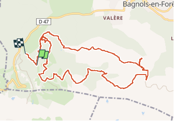

Length
15.1 km

Max alt
435 m

Uphill gradient
598 m
Km-Effort
23 km

Min alt
201 m

Downhill gradient
626 m
Boucle
No
Creation date :
2024-11-16 07:45:00.0
Updated on :
2024-11-16 16:15:57.014

FREE GPS app for hiking
 SityTrail
IGN / Geographical institutes
SityTrail Plus
The world is yours!
About
Trail of 15.1 km to be discovered at Provence-Alpes-Côte d'Azur, Var, Bagnols-en-Forêt. This trail is proposed by GeorgesV..
Description
Randonnée BF Janna
Positioning
Country:
France
Region :
Provence-Alpes-Côte d'Azur
Department/Province :
Var
Municipality :
Bagnols-en-Forêt
Location:
Unknown
Start:(Dec)
Start:(UTM)
310717 ; 4821428 (32T) N.
Comments