


reco Ternay effective 16 11 2024

couxinel
User
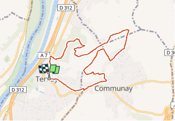

Length
9.8 km

Max alt
301 m

Uphill gradient
191 m
Km-Effort
12.4 km

Min alt
180 m

Downhill gradient
189 m
Boucle
Yes
Creation date :
2024-11-16 13:04:37.474
Updated on :
2024-11-17 06:12:36.005
2h48
Difficulty : Difficult

FREE GPS app for hiking
 SityTrail
IGN / Geographical institutes
SityTrail Plus
The world is yours!
About
Trail Walking of 9.8 km to be discovered at Auvergne-Rhône-Alpes, Rhône, Ternay. This trail is proposed by couxinel.
Positioning
Country:
France
Region :
Auvergne-Rhône-Alpes
Department/Province :
Rhône
Municipality :
Ternay
Location:
Unknown
Start:(Dec)
Start:(UTM)
641091 ; 5051909 (31T) N.
Comments