


Gorges de St Pierre

Nicomontagnes
User

Length
17.3 km

Max alt
2013 m

Uphill gradient
1015 m
Km-Effort
31 km

Min alt
1169 m

Downhill gradient
1020 m
Boucle
Yes
Creation date :
2015-05-29 00:00:00.0
Updated on :
2015-05-29 00:00:00.0
5h22
Difficulty : Unknown

FREE GPS app for hiking
 SityTrail
IGN / Geographical institutes
SityTrail Plus
The world is yours!
About
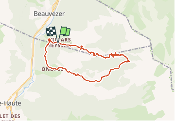
Trail Walking of 17.3 km to be discovered at Provence-Alpes-Côte d'Azur, Alpes-de-Haute-Provence, Beauvezer. This trail is proposed by Nicomontagnes.
Description
Boucle par Villars Heyssier, l'Orgeas, Ondres
Positioning
Country:
France
Region :
Provence-Alpes-Côte d'Azur
Department/Province :
Alpes-de-Haute-Provence
Municipality :
Beauvezer
Location:
Unknown
Start:(Dec)
Start:(UTM)
307889 ; 4888922 (32T) N.
Comments
tres belle randonnée. ..