


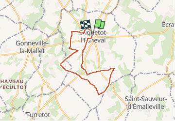
criquetot l'esneval

RoMo
User

Length
12.5 km

Max alt
132 m

Uphill gradient
93 m
Km-Effort
13.7 km

Min alt
108 m

Downhill gradient
94 m
Boucle
Yes
Creation date :
2024-11-17 08:00:59.561
Updated on :
2024-11-17 12:22:00.962
2h42
Difficulty : Medium

FREE GPS app for hiking
 SityTrail
IGN / Geographical institutes
SityTrail Plus
The world is yours!
About
Trail Walking of 12.5 km to be discovered at Normandy, Seine-Maritime, Criquetot-l'Esneval. This trail is proposed by RoMo.
Description
boucle
Positioning
Country:
France
Region :
Normandy
Department/Province :
Seine-Maritime
Municipality :
Criquetot-l'Esneval
Location:
Unknown
Start:(Dec)
Start:(UTM)
302640 ; 5502802 (31U) N.
Comments