


Vers Ligneuville

Alainconnu
User
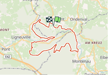

Length
19.5 km

Max alt
578 m

Uphill gradient
509 m
Km-Effort
26 km

Min alt
374 m

Downhill gradient
507 m
Boucle
Yes
Creation date :
2024-11-17 08:47:58.227
Updated on :
2024-11-17 15:06:59.886
5h00
Difficulty : Easy

FREE GPS app for hiking
 SityTrail
IGN / Geographical institutes
SityTrail Plus
The world is yours!
About
Trail Walking of 19.5 km to be discovered at Wallonia, Liège, Waimes. This trail is proposed by Alainconnu.
Positioning
Country:
Belgium
Region :
Wallonia
Department/Province :
Liège
Municipality :
Waimes
Location:
Unknown
Start:(Dec)
Start:(UTM)
293268 ; 5585312 (32U) N.
Comments