


Sommet des Anges

orsel
User GUIDE
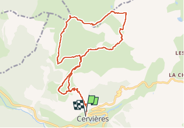

Length
12.2 km

Max alt
2446 m

Uphill gradient
801 m
Km-Effort
23 km

Min alt
1638 m

Downhill gradient
822 m
Boucle
Yes
Creation date :
2024-11-17 07:55:55.204
Updated on :
2024-11-17 17:47:39.766
6h49
Difficulty : Medium

FREE GPS app for hiking
 SityTrail
IGN / Geographical institutes
SityTrail Plus
The world is yours!
About
Trail Walking of 12.2 km to be discovered at Provence-Alpes-Côte d'Azur, Hautes-Alpes, Cervières. This trail is proposed by orsel.
Photos

Positioning
Country:
France
Region :
Provence-Alpes-Côte d'Azur
Department/Province :
Hautes-Alpes
Municipality :
Cervières
Location:
Unknown
Start:(Dec)
Start:(UTM)
319818 ; 4971181 (32T) N.
Comments