


limont anthisnes

lerson
User
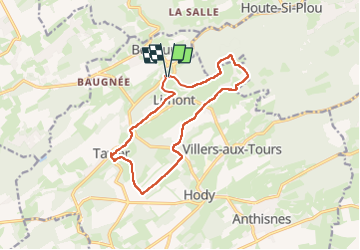

Length
12.4 km

Max alt
284 m

Uphill gradient
250 m
Km-Effort
15.7 km

Min alt
181 m

Downhill gradient
247 m
Boucle
Yes
Creation date :
2024-11-17 12:03:09.038
Updated on :
2025-03-05 15:13:24.03
3h34
Difficulty : Difficult

FREE GPS app for hiking
 SityTrail
IGN / Geographical institutes
SityTrail Plus
The world is yours!
About
Trail Walking of 12.4 km to be discovered at Wallonia, Liège, Anthisnes. This trail is proposed by lerson.
Positioning
Country:
Belgium
Region :
Wallonia
Department/Province :
Liège
Municipality :
Anthisnes
Location:
Unknown
Start:(Dec)
Start:(UTM)
676582 ; 5598608 (31U) N.
Comments