


Saint Zacharie Sources des Nayes reco 14 novembre 2014

rlebasque
User
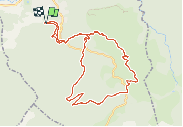

Length
13 km

Max alt
556 m

Uphill gradient
463 m
Km-Effort
19.2 km

Min alt
270 m

Downhill gradient
466 m
Boucle
Yes
Creation date :
2024-11-14 08:17:58.934
Updated on :
2024-11-18 15:35:33.678
5h25
Difficulty : Very difficult

FREE GPS app for hiking
 SityTrail
IGN / Geographical institutes
SityTrail Plus
The world is yours!
About
Trail Walking of 13 km to be discovered at Provence-Alpes-Côte d'Azur, Var, Saint-Zacharie. This trail is proposed by rlebasque.
Positioning
Country:
France
Region :
Provence-Alpes-Côte d'Azur
Department/Province :
Var
Municipality :
Saint-Zacharie
Location:
Unknown
Start:(Dec)
Start:(UTM)
719389 ; 4805912 (31T) N.
Comments