


R1T-SA-Étangs de la Bièvre

CSR-94
User
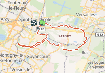

Length
20 km

Max alt
184 m

Uphill gradient
305 m
Km-Effort
24 km

Min alt
106 m

Downhill gradient
303 m
Boucle
Yes
Creation date :
2024-11-17 07:44:05.0
Updated on :
2024-11-27 21:08:50.015
5h31
Difficulty : Very difficult

FREE GPS app for hiking
 SityTrail
IGN / Geographical institutes
SityTrail Plus
The world is yours!
About
Trail Walking of 20 km to be discovered at Ile-de-France, Yvelines, Saint-Cyr-l'École. This trail is proposed by CSR-94.
Points of interest

Positioning
Country:
France
Region :
Ile-de-France
Department/Province :
Yvelines
Municipality :
Saint-Cyr-l'École
Location:
Unknown
Start:(Dec)
Start:(UTM)
431765 ; 5404742 (31U) N.
Comments